The introductions of the country, dependency and region entries are in the native languages and in English. The other introductions are in English.
|
|
| Новороссия
Новоросія
(Novorossiya) |
|
|
| English | Novorossiya - Federal State of Novorossiya
The Federal State of Novorossiya (New Russia) (Russian: Федеративное государство Новороссия, Federativnoye Gosudarstvo Novorossiya; Ukrainian: Федеративна держава Новоросія, Federatyvna derzhava Novorosiya), also referred to as the Union of People's Republics (Russian: Союз Народных Республик, Soyuz Narodnykh Respublik; Ukrainian: Союз Народних Республік, Soyuz Narodnykh Respublik), is a self-proclaimed confederation of Donetsk People's Republic and Lugansk People's Republic, claiming the territory of Donetsk Oblast and Luhansk Oblast in eastern Ukraine, which share a border with Russia. It was declared on 22 May 2014 and agreements were signed between the leaders of the two self-proclaimed republics on 24 May.
|
|
|
| Short name | Novorossiya |
| Official name | Federal State of Novorossiya |
| Status | De-facto independent country since 2014, de jure part of Ukraine |
| Location | East Europe |
| Capital | Donetsk |
| Population | inhabitants |
| Area | km² |
| Major languages | Russian, Ukrainian |
| Major religions | Orthodoxy |
| More information | Novorossiya, Geography of Novorossiya, History of Novorossiya and Politics of Novorossiya |
| More images | Novorossiya - Novorossiya (Category). |
|
General maps
 | Claimed borders of Novorossiya |
 | Claimed borders of Novorossiya |
 | De facto borders of Novorossiya |
 | De facto borders of Novorossiya |
 | De facto borders of Novorossiya |
 | De facto borders of Novorossiya |
 | De facto borders of Novorossiya |
 | De facto borders of Novorossiya |
 | De facto borders of Novorossiya |
 | De facto borders of Novorossiya |
 | De facto borders of Novorossiya |
History maps
This section holds a short summary of the history of the area of present-day New Russia, illustrated with maps, including historical maps of former countries and empires that included present-day New Russia.
 | Historical map of territory of Zaporozhian Cossacks in the early 18th century |
 | Map of cossaks territories in 1740-1750 |
 | Slavo-Serbia in the 18th century |
 | Slavo-Serbia in the 18th century |
 | Slavo-Serbia in the 18th century |
 | Location map of Slavo-Serbia (1753-1764) |
 | Location map of Slavo-Serbia (1753-1764) |
 | Detailed map of Slavo-Serbia (1753-1764) |
 | Detailed map of Slavo-Serbia (1753-1764) |
 | Region in 1772 |
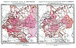 | Administrative division of Russia 1848-1878 (in Russian) |
 | Novorossiya in the Russian Empire |
 | The Russian Empire in 1914 |
 | History of the Russian Empire (in German) |
 | Novorossiya guvernorate in the end of the 18th century |
 | Novorossiya guvernorate in 1800 |
 | Historical Novorossiya (Novorrosiya Region) |
 | Historical Novorossiya (Novorrosiya Region) |
 | Historical Novorossiya (Novorrosiya Region) |
 | Region in 1918 |
 | Donetsk–Krivoy Rog Soviet Republic in 1918 |
 | Administrative divisions of Ukraine 1918 |
 | Region in March 1919 |
 | Region in November 1919 |
 | European part of the USSR in the 1920s |
This file has annotations. Move the mouse pointer over the image to see them.
| Administrative divisions of Ukraine 1921 |
 | Administrative divisions of Ukraine 1921 |
 | Administrative divisions of Ukraine 1927 |
 | Administrative divisions of Ukraine 1932-1937 |
 | Administrative divisions of Ukraine 1937-1939 |
 | Administrative divisions of Ukraine 1939-1940 |
 | Administrative divisions of Ukraine 1940-1945 |
This file has annotations. Move the mouse pointer over the image to see them.
| Eastern front of the Second World War circa 1941-1942. |
 | Administrative divisions of Ukraine 1946-1954 |
 | Soviet Union administrative divisions, 1989 |
Demographics
 | Linguistical map of Ukraine |
 | Map of Russian speakers in Ukraine, based on the |


.PNG)


No comments:
Post a Comment